Property Record
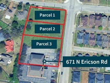
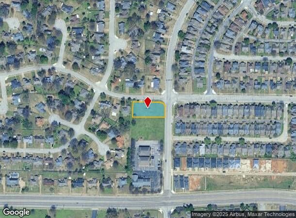
N Ericson Rd, Cordova, TN 38018
NEARBY LISTINGS FOR SALE OR LEASE
Property Detail
N Ericson Rd
Memphis, TN-MS-AR
Part Sunset Downs Pd Outline Plan
09-1053-0-0058
SS OVERCUP OAKS DR COR NORTH ERICSON RD DRIVE (SW) SEE MAP D2-14L
Vacantlandnec
Shelby
X
Tennessee
47157C0320G
0.49 AC
2024
Northeast
2025
Memphis
021144
DEMOGRAPHICS near N Ericson Rd
1 Mile
3 Mile
5 Mile
2024 Total Population
8,152
57,052
139,052
2029 Population
7,918
55,706
135,319
Pop Growth 2024-2029
(2.87%)
(2.36%)
(2.68%)
Average Age
39
39
39
2024 Total Households
3,288
22,962
55,261
HH Growth 2024-2029
(3.04%)
(2.40%)
(2.73%)
Median Household Inc
$78,053
$81,067
$82,774
Avg Household Size
2.40
2.40
2.50
2024 Avg HH Vehicles
2.00
2.00
2.00
Median Home Value
$215,990
$243,691
$276,687
Median Year Built
1993
1993
1991
Nearby Places
Map Layers
Map Styles
 Street
 Aerial
- Restaurants
- Banks
- Shops
- Fitness
- Groceries
PUBLIC TRANSPORTATION
AIRPORT
Memphis International
DRIVE
WALK
Distance
Memphis International
29 min
19.0 mi
Freight Ports
Port of Shreveport
DRIVE
WALK
Distance
Port of Shreveport
425 min
389.0 mi
SALE & LEASE HISTORY
LISTING DATE
SALE/LEASE

Feb 13, 2025
For Sale
Nearby Properties
Address
Land Use
TOTAL SIZE
Lot Size
Zoning
Address
Land Use
TOTAL SIZE
Lot Size
Zoning
92,452 SF
5 AC
O
Address
Land Use
TOTAL SIZE
Lot Size
Zoning
325,370 SF
64.04 AC
CA
Address
Land Use
TOTAL SIZE
Lot Size
Zoning
175,984 SF
22.75 AC
RU-4
Address
Land Use
TOTAL SIZE
Lot Size
Zoning
30.93 AC
R
Address
Land Use
TOTAL SIZE
Lot Size
Zoning
1,919.25 AC
CA
Address
Land Use
TOTAL SIZE
Lot Size
Zoning
57,751 SF
7.36 AC
O
Address
Land Use
TOTAL SIZE
Lot Size
Zoning
196,088 SF
5.28 AC
C-2
Address
Land Use
TOTAL SIZE
Lot Size
Zoning
358,137 SF
32.19 AC
RU-3
Address
Land Use
TOTAL SIZE
Lot Size
Zoning
159,917 SF
9.61 AC
O-51
Address
Land Use
TOTAL SIZE
Lot Size
Zoning
171,906 SF
7.52 AC
RU-3
Address
Land Use
TOTAL SIZE
Lot Size
Zoning
64,002 SF
67.10 AC
RU-2
Address
Land Use
TOTAL SIZE
Lot Size
Zoning
50,534 SF
4.32 AC
O
Address
Land Use
TOTAL SIZE
Lot Size
Zoning
260,599 SF
28.13 AC
CA
Address
Land Use
TOTAL SIZE
Lot Size
Zoning
31,562 SF
27.68 AC
R-T
Address
Land Use
TOTAL SIZE
Lot Size
Zoning
83,821 SF
39.50 AC
RU-3
Address
Land Use
TOTAL SIZE
Lot Size
Zoning
93,713 SF
17.70 AC
CA
Address
Land Use
TOTAL SIZE
Lot Size
Zoning
91,232 SF
21.66 AC
IH
Address
Land Use
TOTAL SIZE
Lot Size
Zoning
35,313 SF
22.81 AC
RU-3
Address
Land Use
TOTAL SIZE
Lot Size
Zoning
54,560 SF
17.29 AC
RU-2
Address
Land Use
TOTAL SIZE
Lot Size
Zoning
64,807 SF
6.08 AC
C-2
Address
Land Use
TOTAL SIZE
Lot Size
Zoning
50,218 SF
30.77 AC
R-T
Address
Land Use
TOTAL SIZE
Lot Size
Zoning
43.88 AC
R-10
Address
Land Use
TOTAL SIZE
Lot Size
Zoning
105,950 SF
21.19 AC
RU-3
Address
Land Use
TOTAL SIZE
Lot Size
Zoning
234,360 SF
22.12 AC
IH
Address
Land Use
TOTAL SIZE
Lot Size
Zoning
29,090 SF
22.71 AC
CA
Address
Land Use
TOTAL SIZE
Lot Size
Zoning
166,912 SF
15.41 AC
CA
Address
Land Use
TOTAL SIZE
Lot Size
Zoning
223,023 SF
20.31 AC
IH
Address
Land Use
TOTAL SIZE
Lot Size
Zoning
89,149 SF
25.56 AC
RU-3
Address
Land Use
TOTAL SIZE
Lot Size
Zoning
35,661 SF
25.53 AC
CA
Address
Land Use
TOTAL SIZE
Lot Size
Zoning
65,907 SF
8.34 AC
IH
The World's #1 Commercial Real Estate Marketplace
Connect with us
© 2025 CoStar Group
The information above has been obtained from sources believed reliable. While we do not doubt its accuracy we have not verified it and make no guarantee, warranty or representation about it. It is your responsibility to independently confirm its accuracy and completeness. Any projections, opinions, assumptions, or estimates used are for example only and do not represent the current or future performance of the property. The value of this transaction to you depends on tax and other factors which should be evaluated by your tax, financial, and legal advisors. You and your advisors should conduct a careful, independent investigation of the property to determine to your satisfaction the suitability of the property for your needs.